Information about the trekking excursion on the Julian Alps
The trekking itinerary Anello delle Alpi Giulie is demanding but highly fascinating. It crosses the rocky Karst Plateau along ledges, trails and via ferratas.
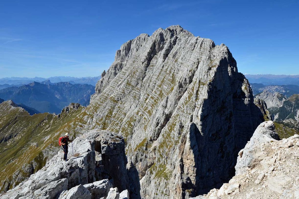
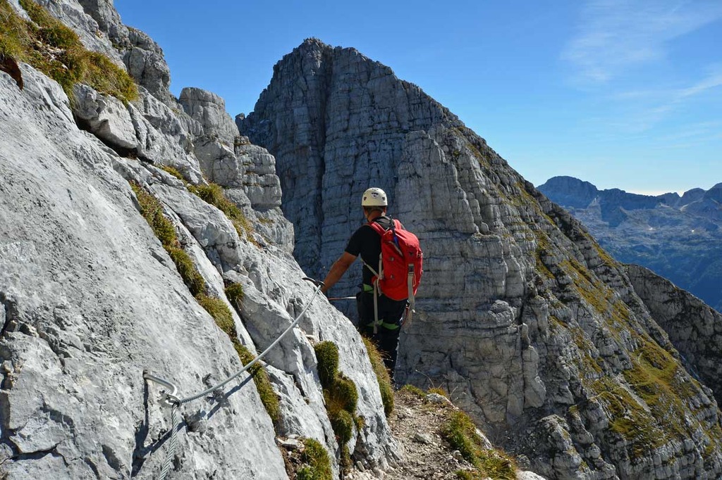
The Via Ferrata "Anita Goitan" is one of the most beautiful and popular via ferratas of the Friuli Venezia Giulia region, opened by the great mountaineer Emilio Comici, completely equipped in 1973 and dedicated to the renowned mountaineer and writer Anita Goitan. Then we would like to mention the Sentiero Attrezzato del Centenario, a via ferrata built by the C.A.I. section of Gorizia (Italian Alpine Club) to celebrate the 100th anniversary of the section, the ascent to Jôf Fuart (2666 metres), the Via Ferrata Amalia to Jôf di Montasio and the Via Ferrata Italiana to Mangart.
The itinerary is physically demanding and requires good "via ferrata skills", but you will be repaid by the amazing wild landscapes of this pristine, harsh and fascinating Alps environment.
Trekking excursion programme and itinerary
Day 1
From the town of Tolmezzo we will reach by car Sella Nevea (1122 metres), starting point of the trekking excursion. Then we will ascend along the trail that dates back to WWI to reach Passo degli Scalini (2022 metres) and descend to the mountain hut Rifugio Corsi (1874 metres).
Elevation gain: 900 metres. Duration time: three/four hours.
Day 2
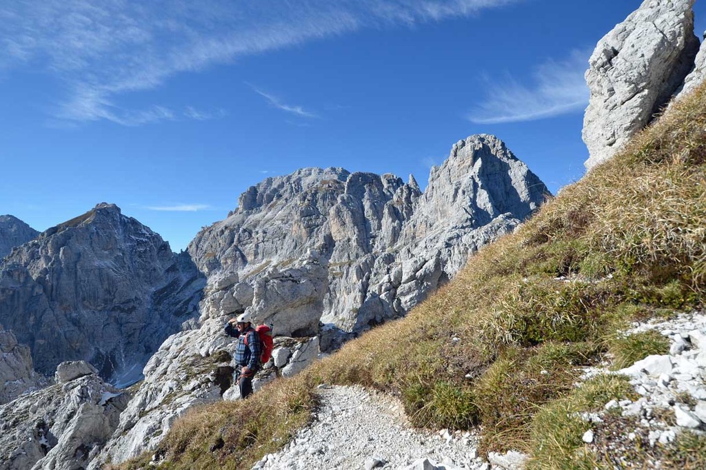
From Rifugio Corsi we will ascend to Forcella Mosè (2271 metres) and then ascend the A. Goitan trail that leads to the summit of Jôf Fuart (2666 metres). Then we will come back along the same trail and descend to Forcella Riofreddo and to Vallone di Riofreddo. Finally we will pass Forcella Carnizza (1767 metres) and reach the hut Rifugio Pellarini (1499 metres).
Elevation gain: 900 metres. Duration time: seven/eight hours.
Day 3
Fom Rifugio Pellarini we will ascend to Sella Nabios (1970 metres) and continue walking along the trail Carlo Chersi (EE) to the Bivacco Dario Mazzeni (1630 metres). Then we will descend to reach Alta Spranga (1140 metres) and ascend again to Bivacco Stuparich (1578 metres). From there a mild slope leads to the hut Rifugio F.lli Grego (1395 metres).
Elevation gain: 900 metres. Duration time: six/seven hours.
Day 4
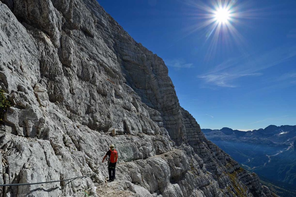
From Rifugio Grego we will go back to Bivacco Stuparich and then ascend below the Montasio glacier (2100 metres), from where we will turn towards the Via Ferrata Amalia to Jôf Montasio (2753 metres) and then reach the Bivacco Suringar (2430 metres) through via ferrata pitches and mountaineering ascents, to finally descend to the hut Rifugio G. Brazzà (1660 metres).
Elevation gain: 1050 metres. Duration time: eight/nine hours.
Day 5
From Rifugio Brazzà we will descend to Sella Nevea, and from there ascend along a trail to reach the hut Rifugio Gilberti (1850 metres).
Elevation gain:750 metres. Duration time: five/six hours.
Day 6
From Rifugio Gilberti we will ascend to the Canin glacier, progress along the Via Ferrata Julia and reach the summit of Monte Canin (2587 metres). Then we will descend along the route Via delle Cenge, go back to the Rifugio Gilberti and get by cable car to Sella Nevea. End of the trekking excursion.
Elevation gain: 750 metres. Duration time: five/six hours.
Mangart Variant
Day 5
From Rifugio Brazzà we will descend to Sella Nevea, then transfer to the Fusine lakes and ascend to reach the hut Rifugio Zacchi (1380 metres).
Day 6
From the hut we will descend to Alpe Vecchia and then ascend along a trail to Bivacco Nogara (1850 metres). Not far from there, there is the starting point of Via Ferrata Italiana al Mangart that ends up exactly on the border line between Italy and Slovenia. From the via ferrata arrival point we will progress along the ledges and equipped pitches of the route Via Normale al Mangart (2677 metres), where the view is 360 degree wide over the mountains, this panorama being one of the most beautiful of the Julian Alps. We will descend along the Via Ferrata Slovena to reach the pass Forcella Lavina and then, along a trail, we will reach again Bivacco Nogara and the car park.
Elevation gain: 1300 metres. Duration time: eight hours.
"Soft" three or four-day trekking itinerary and programme
Day 1
Trasfer to Sella Nevea (1122 metres), starting point of the trekking excursion. From the cableway car parck we will take the trail 625 that stretches out initially into a spruce and larch wood and then across wide meadows from where to enjoy amazing views of the Canin, Mangart and Jalovec massifs. We will ascend along the trail that dates back to WWI to reach Passo degli Scalini (2022 metres) and then descend to the hut Rifugio Corsi (1874 metres).
Elevation gain: 900 metres. Duration time: three/four hours.
Day 2
From Rifugio Corsi we will take the trail 625-627, after approximately ten minutes we will reach a crossroads from where we will take the trail 627 and then leave it to traverse towards right to reach Forcella Riofreddo (2180 metres). The trail continues below the summit of Cima di Riofreddo then goes along a gorge and reaches finally the narrow Forcella di Riofreddo where the equipped route Sentiero Attrezzato Anita Goitan begins. The Anita Goitan trail starts on easy rocks, then continues on not too overhanging ledges to traverse diagonally the peak Cima di Riofreddo to reach a narrow couloir where the route Via normale goes up to the summit. We wil pass the narrow couloir keeping the left, to reach some handy ledges and a few cracks that are deep but well equipped with steel cables and handholds, that help the climber to circumvent a few pinnacles: La Torre and L’Alta Madre dei Camosci. Proceeding straight, we will ascend 50 metres and then cross the meadow on the south side of Jôf Fuart to finally see the signpost of the route Via Normale to Jôf Fuart on the right. We will ascend that route to reach the rocky crest that leads to the summit of Jof Fuart (2666 metres). Then we will descend towards South to reach the juncture with the trail that, along some steep rills, leads to the pass Forcella Mosè (2271 metres). From Forcella Mosè it is possible to continue along the Sentiero Attrezzato Anita Goitan to reach the summit of Cima Castrein, with its old military outposts, or descend along the trail back to Rifugio Corsi. Then we will ascend again towards Cime Castrein, along some equipped pitches and grassy slopes. While climbing along the crest, you will see plenty of outposts and trails that date back to WWI. The descent to Forcella Lavinal dell’Orso (2271 metres) goes along a trail that crosses the meadows until we see again the signpost of the path to Rifugio Corsi.
Elevation gain: 900 metres. Duration time: seven/eight hours.
Day 3
From the hut Rifugio Guido Corsi we will ascenfd towards Jôf Fuart to reach the juncture to Forcella di Riofreddo (2180 metres) and Forcella del Vallone (2180 metres). The trail towards the latter becomes more and more steep and gravelly until it reaches the path Sentiero Attrezzato del Centenario. This Via Ferrata stretches out along the sharp crests of Cime Piccole di Riobianco (2206 metres). Passing a ledge, we will enter a narrow former military tunnel, that was dug during the First World War in the rocks of the peak Cima delle Forcelle. A ladder enables climbers to get out of the tunnel on the south face. We will not climb up to the summit, but will descend along a crack equipped with ladders and steel cable. Then we will ascend along a rill to the pass Forcella Alta di Riobianco (2150 metres). From there we will descend along a pebbly rill and after 20 minutes reach the Bivacco Gorizia (1950 metres). We will keep descending along the rill Vallone di Riobianco to reach the juncture wuth the trail 630-625. We leave the trail 630 and take the trail 625 that reaches the former hut Rifugio Brunner (1432 metres). From there we descend along Val Rio del Lago on the trail 625, on the left bank of Rio Bianco, until we reach the carriageway close to the bridge over the trench, which is the arrival point of our trekking tour. From there, we will tranfer back to Sella Nevea.
Elevation gain: 300 metres. Duration time: five hours.
Day 4, optional
From Sella Nevea ascend to Rifugio Gilberti (1850 metres) by cable car. From Rifugio Gilberti ascend along the trail to Canin glacier, crossing the plateau where some of the deepest caves of the world are located. Then progress along the Via Ferrata Julia and reach the summit of Monte Canin (2587 metres). From there, the view is 360° wide on the mountains of Slovenia, Austria, on the Dolomites and even to the Adriatic sea. From the summit, descend along the route Via delle Cenge, an overhanging trail scarcely equipped, or along the ridge on the border between Italy and Slovenia, to reach Forca Prevala. From there descend back to Rifugio Gilberti and then by cable car to Sella Nevea, the arrival point of the trekking tour.
Elevation gain: 750 metres. Duration time:five/six hours.


Contact us for booking or for information
tel. +39 3279311671 - booking@dolomitiskirock.com
Contact us